The site
The study area covers the former extent of the Rye Meads Sewage Treatment Works and adjacent meadows, covering several hectares of sludge beds, lagoons and meadows, and these in turn are adjacent to abandoned gravel pits and marshes. In the 1990s, most of Thames Water’s land to the north of the Rye Road was passed to the RSPB for their management, and is now the bulk of the RSPB Rye Meads Nature Reserve. The Ringing Group continues to study the birds in this part of the site in active co-operation with the RSPB reserve management. The remaining meadows and former gravel workings north of the Rye Road form the HMWT Reserve. We also continue to study the southern area of the site, comprising the treatment works and settlement lagoons, by arrangement with the site owner, Thames Water.
Much of the site and the surrounds have been designated a Site of Special Scientific Interest (SSSI). In addition, it is a designated Special Protection Area (SPA) and also listed as a Wetland of International Importance under the "Ramsar convention".
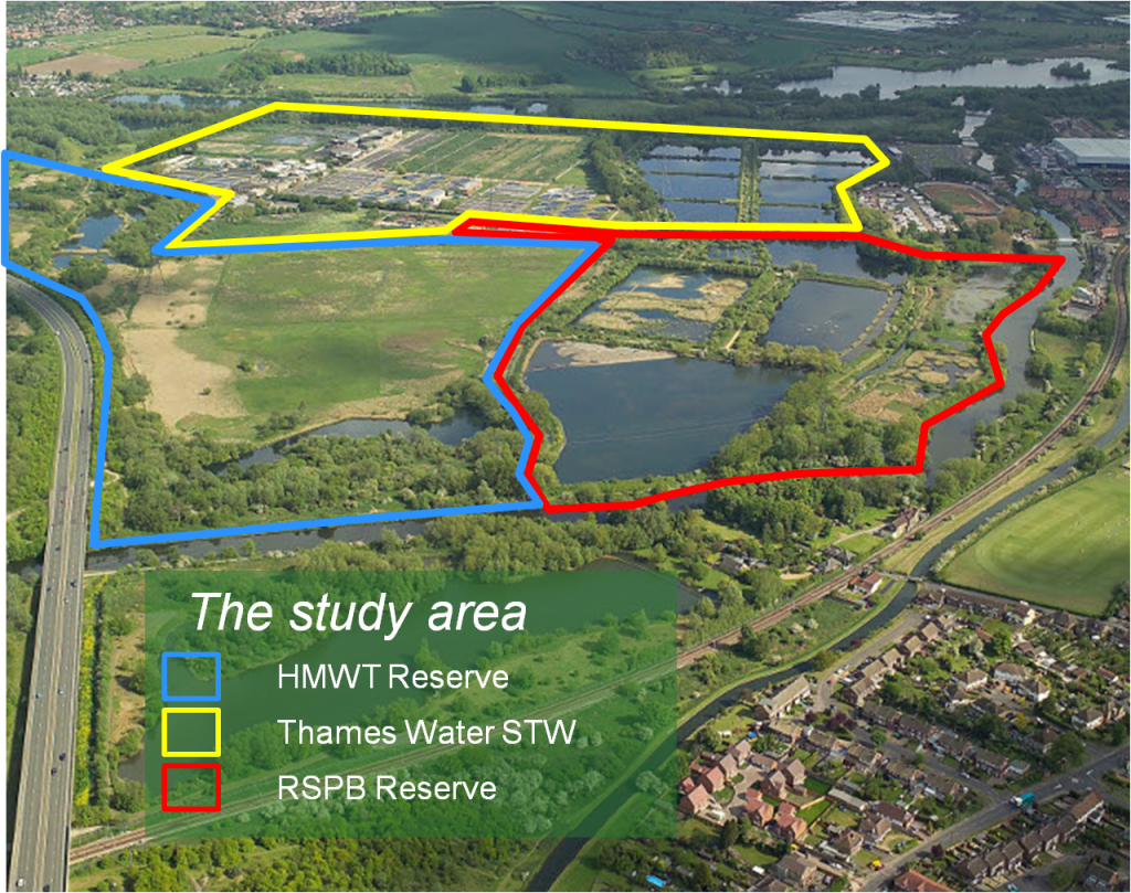
A map of the Rye Meads site
Outlined in red – the Partnership Recording Area
Outlined in yellow – the Core Area for RMRG (focus of breeding surveys)
Map data ©2016 Google Imagery ©2016 Bluesky, DigitalGlobe, Getmapping plc, Infoterra Ltd & Bluesky, Landsat
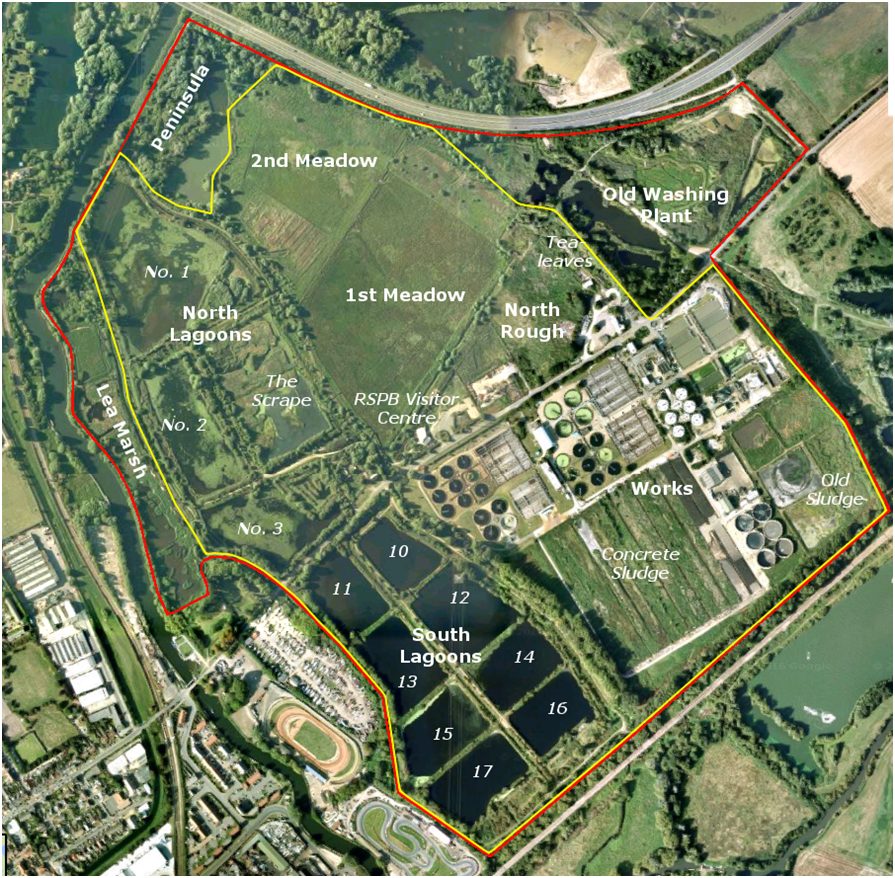
The study area currently divides into six main areas. These are shown on the map.
To the north of the Rye Road (the toll road that runs through the middle of the area and on which the RSPB Visitor Centre stands), there are the North Lagoons and the Lee Marsh, which together comprise the area of the RSPB Reserve west of the Tollhouse Stream. Then to the east of the Tollhouse Stream there are the Meadows, which are part of the HMWT Reserve, and finally the North Rough which is Thames Water land.
South of the Rye Road is the Thames Water Sewage Treatment Plant. This can be considered in two parts: firstly, the Works, which is east of the Tollhouse Stream, and is the industrial site where TW has the plant for treating sewage; secondly, the South Lagoons, which is to the west of the Tollhouse Stream and is where water flowing out of the sewage works passes through a series of settlement lagoons enabling residual solid particles still in the water to settle out before flowing out into the Tollhouse Stream and thence to the River Stort at the southern edge of the site.
The main netting sites are as follows: the North CES, which runs along the eastern side of the Scrape, and South CES, which is on the eastern edge of 14 and 16 Lagoons; the Bund, a spit of land through the large reedbed at the northern end of the Scrape; the Centre Channel, which runs down the centre of the eight South Lagoons; the Concrete Sludge, using a currently disused area in the Works, and the Tealeaves, which is part of the North Rough. There are various other sites used occasionally when the opportunity arises, and several permanent duck traps.
History of the site
The most notable event in Rye Meads history was the infamous Rye House Plot of 1683. At that time the Rye Road was the main crossing of the Lea Valley, then largely marshland, although the Rye House Gatehouse is actually a Victorian folly and doesn’t date from this period. The Plot was a conspiracy to ambush and kill King Charles II and his brother and heir to the throne, James, as they returned along Rye Road from the races at Newmarket, in order to prevent the crown from becoming Catholic. The Plot was discovered and thwarted.
More recently, in the late nineteenth century, much of the area was developed as watercress beds, and then in the first half of the twentieth century the first small sewage farm was established.
The major developments leading to the current Sewage Treatment Works came in the 1950s and can be seen from the aerial photographs shown here. More organised bird recording also began around this time, and then in 1960 the Rye Meads Ringing Group was established.
The RSPB reserve began in the early 1970s as a small operation based on the Lea Marsh only, and in the 1990s changes in sewage treatment meant that there was no longer a need for the North Lagoons to be part of this process, and the area was leased by Thames Water to the RSPB to create the present extent of the RSPB Reserve. In 1998 four small lagoons were merged and reshaped to create the Scrape, and planted with reeds to create the habitat seen today.
Gallery of site views
(click on image to enlarge)
Stages in the development of the site


, the development of the Works area is under way, but the lagoons have not yet been developed.")


Views of the current site


")

")
")
")

")
")
")
")
")

")
")
")
")
")
")
")